| configure |
Detailed indicators |
| Measuring performance |
Signal tracking |
1008aisle |
| BDS-2:B1I,B2I,B3I |
| BDS-3:B1I,B3I,B1C,B2a,B2b |
| GPS: L1C/A, L2P, L2C, L5, L1C* |
| GLONASS: G1,G2,G3* |
| Galileo:E1,E5b,E5a,E5 AltBoc*,E6c* |
| SBAS:L1C/A,L5* |
| QZSS:L1,L2C,L5I |
| RNSS:L5* |
| GNSS features |
Positioning output frequency 1Hz~50Hz |
| Initialization time is less than 10 seconds |
| Initialization reliability >99.99% |
| Full constellation reception technology capable of supporting signals from all current and planned GNSS constellations |
| Highly reliable carrier tracking technology to improve carrier accuracy and provide high-quality original observation data |
| Intelligent dynamic sensitivity positioning technology, adapt to various environmental changes, adapt to harsh, long-distance positioning environment |
| High-precision positioning processing engine |
| positioning accuracy |
Code Differential GNSS Positioning |
Horizontal: 0.25 m + 1 ppm RMS |
| Vertical: 0.50 m + 1 ppm RMS |
| SBAS differential positioning accuracy: typical <5m 3DRMS |
| Static measurement accuracy |
Plane: ±(2.5mm+0.5×10⁻⁶D) |
| Elevation: ±(5mm+0.5×10⁻⁶D) |
| (D is the measured baseline length) |
| RTK measurement accuracy |
Plane: ±(8mm+1×10⁻⁶D) |
| Elevation: ±(15mm+1×10⁻⁶D) |
| (D is the measured baseline length) |
| operating system/ |
operating system |
Linux |
| User interaction |
button |
Two-button operation, convenient and quick |
|
LCD screen |
1.3 inch OLED color screen |
|
indicator light |
Four indicator lights |
|
web interaction |
Built-in Web UI management background, support WiFi and USB modes to access the receiver’s built-in Web UI management page, monitor the host status in real time, and configure the host freely. |
|
voice |
iVoice intelligent voice technology, intelligent status broadcast, voice operation prompt; |
|
Support Chinese, English, Korean, Russian, Portuguese, Spanish, Turkish by default; support voice customization |
|
Secondary development |
Provide secondary development package, open OpenSIC observation data format and interactive interface definition for secondary development |
|
Data cloud service |
Web version cloud service management platform, support online registration and other remote management, data interaction and other services |
| hardware |
size |
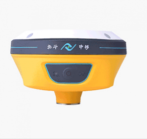
166*166*96.5 |
| weight |
≈1.3KG |
| material |
magnesium alloy |
| temperature |
Operating temperature: –25 °C to +65 °C |
| Storage temperature: –40 °C to +80 °C |
| humidity |
100% resistant to condensation |
| Protection class |
Waterproof: 1m immersion, IP68 |
| Dustproof: Completely prevent dust from entering, IP68 |
| shockproof |
Resist 2 meters drop with the pole |
| electric |
power supply |
9-28V wide voltage DC design, with overvoltage protection |
| Battery |
High capacity built-in battery 10000mAh 7.4V |
| Power Solutions |
Routine operations meet 16 hours of battery life, support rod-shaped battery rod power supply, and can support other transformer power supply systems, |
| (Provide 7*24h continuous working power solution) |
| communication |
I/O ports |
5PIN LEMO external power interface + RS232 |
| Type-C interface supports charging, power supply and data transmission |
| 1 radio data link antenna interface |
| SIM card slot (medium card) |
| radio modem |
Built-in transceiver integrated radio, the typical operating distance is 15km |
| Support network relay, radio relay mode |
| Operating frequency 410-470MHz |
| Communication protocol: Instant, TrimTalk450S, ZHD,, HUACE,Satel |
| cellular |
Intelligent PPP dial-up technology based on Linux platform, automatic real-time dial-up, continuous online during the work process, equipped with 4G full Netcom high-speed network communication module, compatible with various CORS system access. The host has a built-in network antenna, which makes the work easier. Adopt eSIM card technology, embedded eSIM chip, no need to insert a card, provide network resources in real time, ensure the continuous online operation of the host network (optional) |
|
BLE 4.0 standard, support Android system mobile phone connection; 2.1 + EDR standard |
| NFC wireless communication |
Using NFC wireless communication technology, the handbook and the host can be automatically paired with by touching them (the handbook is also required to be equipped with an NFC wireless communication module) |
| WIFI |
standard |
802.11b/g/n standard |
| WIFI hotspot |
With WIFI hotspot function, any smart terminal can be connected to the receiver, and the receiver function can be richly customized; |
| Data collectors such as industrial handbooks and smart terminals can transmit data with the receiver through WIFI |
| WIFI data link |
The receiver can be connected to WIFI to broadcast or receive differential data through WIFI |
| Data storage/transfer |
data storage |
8G built-in solid-state memory, support 32G external expansion; automatic cycle storage (the earliest data will be automatically deleted when the storage space is not enough); support external USB memory for data storage; rich sampling interval, support up to 50Hz original observation data collection |
| data transmission |
One-key smart copy directly exports the static data of the host through an external USB memory; plug-and-play USB data transmission method; HTTP download |
| Data Format |
Static data format: STH, Rinex2.01 and Rinex3.02 and other formats |
| Differential data format: CMR+, CMRx, RTCM 2.1, RTCM 2.3, RTCM 3.0, RTCM 3.1, RTCM 3.2 input and output; GPS output data format: NMEA 0183, PJK plane coordinates, binary code, Trimble GSOF; |
| Inertial Navigation System / Sensors |
electronic bubble |
Built-in sensor, the handbook software can display electronic bubbles, and check the leveling condition of the centering rod in real time |
| Shake tilt measurement |
Core patented algorithm, by swing host, the coordinates are automatically corrected according to the inclination direction and angle of the centering rod. |
| Inertial navigation tilt measurement (optional) |
The built-in IMU inertial measurement sensor supports the inertial navigation tilt measurement function to automatically correct the coordinates according to the tilt direction and angle of the centering rod. |
| Temperature Sensor |
Built-in temperature sensor, using intelligent frequency conversion temperature control technology, real-time monitoring and adjustment of the host temperature |


