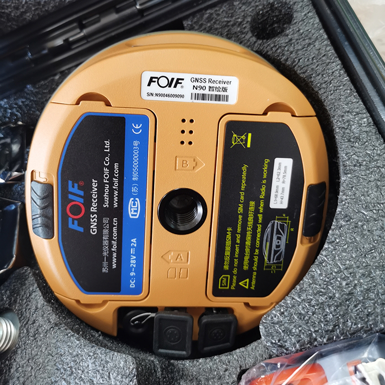
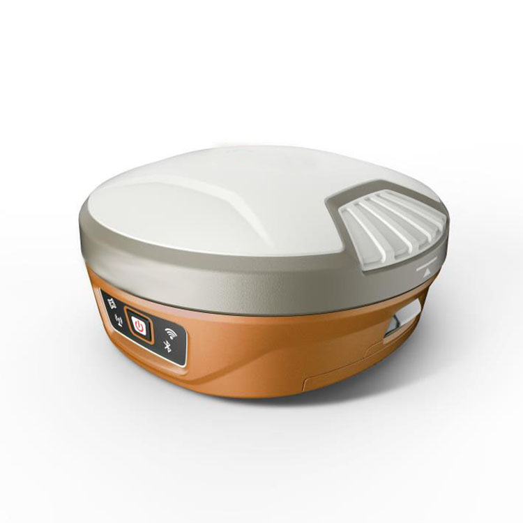
OEM/ODM Manufacturer Mini Rtk - Land surveying instruments with 555 channels gnss receiver Foif N90 – Haodi
OEM/ODM Manufacturer Mini Rtk - Land surveying instruments with 555 channels gnss receiver Foif N90 – Haodi Detail:
Product Detail:
| Items | Specification | |
| GNSS Engine | GNSS board | NovAtel OEM 729 |
| Channel | 555 | |
| Satellites | GPS: L1 C/A, L1C, L2C, L2P, L5 | |
| GLONASS: L1 C/A, L2 C/A, L2P, L3, L5 | ||
| BeiDou: B1, B2, B3 | ||
| Galileo: E1, E5 AltBOC, E5a, E5b, E6 | ||
| NavlC (IRNSS): L5 | ||
| SBAS: L1, L5 | ||
| QZSS: L1 C/A, L1C, L2C, L5, L6 | ||
| L-Band: Up to 5 channels | ||
| Trimble BD990 optional | ||
| Real-Time Accuracy(rms) | SBAS | Horizon: 60cm(1.97ft); Vertical: 120cm(3.94ft) |
| Real-Time DGPS position | Horizon: 40cm(1.31ft); Vertical: 80cm(2.62ft) | |
| Real-Time Kinematic Position | Horizontal: 1cm(0.03ft)+1.0ppm; Vertical: 2.5cm(0.08ft)+1.0ppm | |
| Real-Time Performance | Instant-RTK Intialization | Typically <10s (Intialization for base lines <20km) |
| Stop and Go solution | 99.9% reliability | |
| RTK Intialization range | >40km | |
| Post Processing Accuracy(rms) | Static, Rapid Static | Horizontal: 2.5mm(0.008ft) +1.0ppm; |
| Vertical: 5mm(0.016ft)+1.0ppm | ||
| Post-processing Kinematic | Horizontal: 10mm(0.033ft)+1.0ppm; Vertical: 20mm(0.066ft)+1.0ppm | |
| Solutions | Surpad software | Main function include: A90 GNSS Support: configuration, monitoring and control |
| Field Software Suite | Volume computation, Background raster image | |
| Network connectivity, Coordinate System Support: predefined grid systems, predefined datums | ||
| projections, Geoids, local grid | ||
| Map view with colored lines Geodetic Geometry: intersection, azimuth/distance, offsetting, poly-line, curve, area | ||
| Road Construction (3D): Survey Utilities: calculator, RW5 file | ||
| Viewing: Data import/Export: DXF, SHP, RW5 | ||
| Data logging | Recording Interval | 0.1-999 seconds |
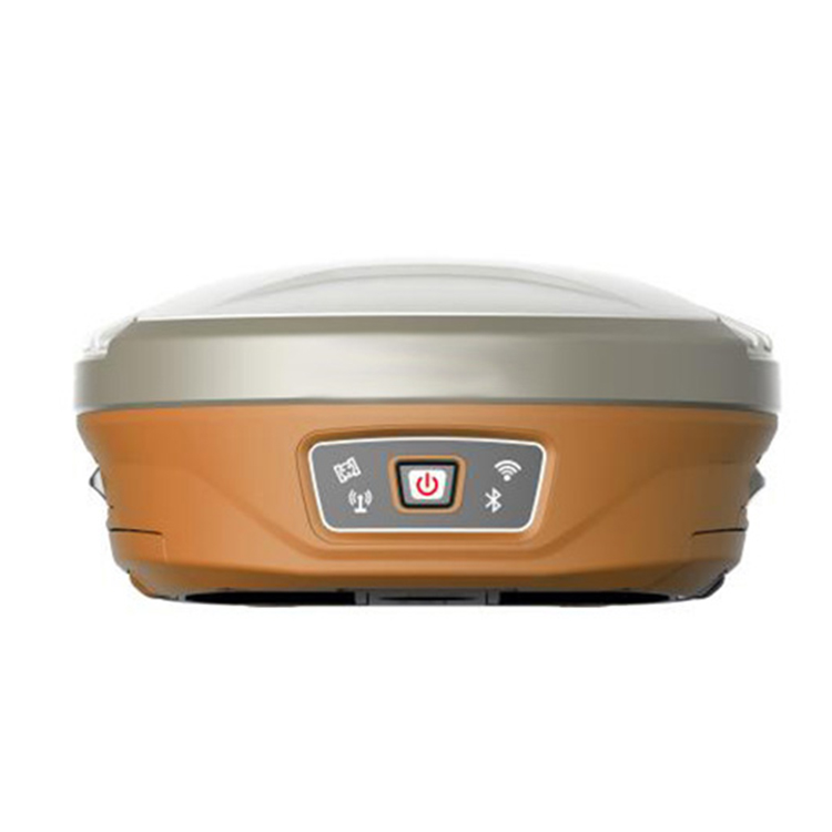
| Physical | Flat design | |
| Size | 156mm*76mm | |
| Bottom cover | Aluminum magnesium alloy | |
| Memory | Internal memory | 8GB standard; supports extending to 32GB |
| I/O Interface | TNC port | connecting built-in radio antenna |
| 5-pin lemo port | connecting external power supply and external radio | |
| 7-pin lemo port | (USB+serial port): connecting PC and handheld | |
| Operating system | Linux | Based on Linux; Supports Web UI |
| Voice | Multi-language supported | |
| Tilt survey sensor | Automatic correct system by 30 degree | |
| Data format | Data format | RTCM 2.3 |
| RTCM 3.0.RTCM 3.X | ||
| CMR, CMR+ | ||
| NovAtelX/5CMRx | ||
| Operation | Operation | RTK rover/base, post-processing |
| RTK Network rover | VRS, FKP, MAC | |
| Point-to-point GPRS through Real-time Data | ||
| Server Software (internal GPRS or external cell phone) | ||
| LandXML (FOIF Field Genius support) | Total Station support ( FOIF Field Genius) | |
| Import and stake directly from a DXF File (FOIF Field Genius) | ||
| Office Software | Main functions include: Network post-processing | |
| Integrated transformation and grid system computations | ||
| Pre-defined datums along with use-defined capabilities | ||
| Survey mission planning | ||
| Automatic vector processing | ||
| Least-squares network adjustment | ||
| Data analysis and quality control tools | ||
| Coordinate transformations | ||
| Reporting | ||
| Exporting | ||
| Geoid | ||
| Environmental | Operating temperature | -30℃ to +65℃(-22°F to 149°F) |
| Storage temperature | -40℃ to +80℃(-40°F to 176°F) | |
| Humidity | 100% condensing | |
| Waterproof | IP67 (IEC60529) | |
| Shock | 2m (6.56ft) pole drop | |
| 1.2m (3.94ft) free drop | ||
| Power | 7.2v.2 removable batteries (total up to 6800mAh, supports single battery working) | |
| Optional System Components | Communication Module | Internal radio: UHF Link (410-470MHz) |
| 1W | ||
| External radio | R*&*both (5w/35w selectable) | |
| 4G LTE module (EC25 series) | Fits various networks | |
| Bluetooth | 2.1+EDR Class 2 | |
| WiFi | IEEE 802.11 b/g/n | |
| Antenna | Built-in antenna, integrating GNSS, BT/WLAN and network antenna | |
| Controller | F58 | |
related pictures
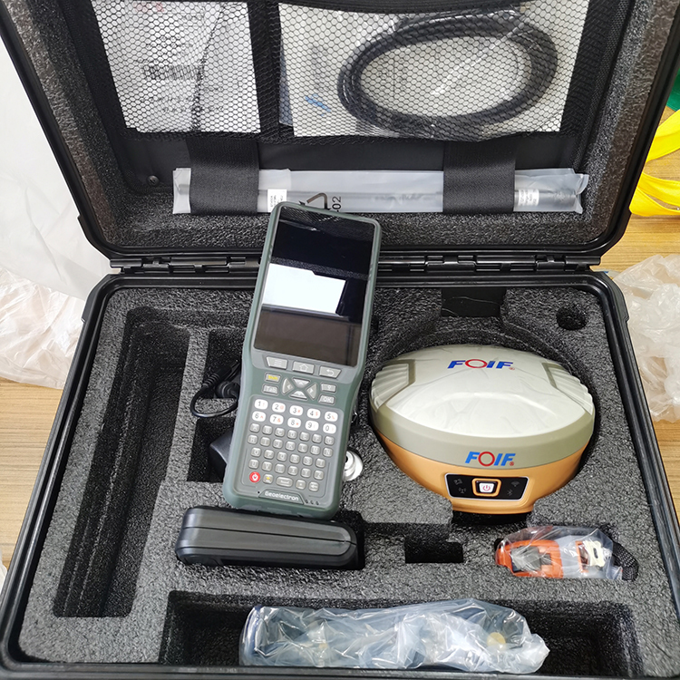
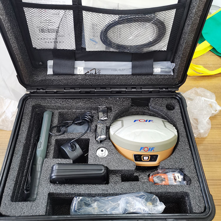
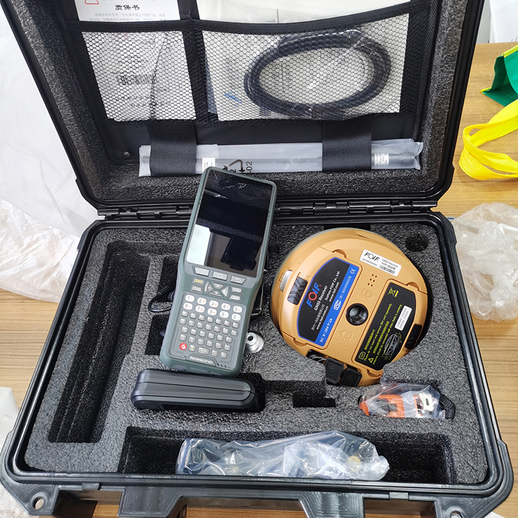
Product detail pictures:
Related Product Guide:
Attaining consumer satisfaction is our company's purpose without end. We will make wonderful endeavours to produce new and top-quality merchandise, satisfy your exclusive requirements and supply you with pre-sale, on-sale and after-sale services for OEM/ODM Manufacturer Mini Rtk - Land surveying instruments with 555 channels gnss receiver Foif N90 – Haodi , The product will supply to all over the world, such as: Poland, Rwanda, Sevilla, High output volume, top quality, timely delivery and your satisfaction are guaranteed. We welcome all inquiries and comments. If you are interested in any of our products or have an OEM order to fulfill, please feel free to contact us now. Working with us will save you money and time.
The sales manager is very patient, we communicated about three days before we decided to cooperate, finally, we are very satisfied with this cooperation!
Products categories
-

OEM/ODM Supplier Leica Gps - High Precision Ko...
-
Manufactur standard Nivel Laser Bosch - Rugged...
-

OEM/ODM Supplier Chcnav I90 - Tribrach And Ada...
-
Good Quality Rtk Gps - CHC X6/I73 Handheld Gns...
-

China OEM Hi-Target Gnss Rtk - Kolida K3 GNSS ...
-

Free sample for V90 Plus Gnss Rtk - 800 channe...